County Surveyor Standards
All survey maps and plats for subdivisions, condominiums, partitions and cemeteries shall meet the following minimum standards and requirements in addition to any standards and requirements prescribed by Oregon Revised Statutes, Oregon Administrative Rules, county ordinances, city ordinances or other similar documents.
All maps shall meet the “basic standard for ink and material.”
The “Basic Standard” is: The ink shall not rub off or smear when a dry finger is rubbed over the material with a medium pressure. There shall not be an embossed (ridge type) feeling when a finger is rubbed over the material. The ink shall be identified by the manufacturer as archival. The polyester drafting film material shall be identified by the manufacture as archival.
- Plat Design
The engineering design of street improvements for manhole, clean-outs and valve locations need to be done in such a manner that they will not interfere with the placement of centerline and/or Public Land Corner monuments. Not only is this a practical matter, but it is also a condition of State law which requires utility infrastructure to not be within one foot of a monument; ORS 92.044(7).
- Plat Easements
Conditions, Covenants and Restrictions (CC&Rs) cannot create easements. As a general rule, CC&Rs are defined as rules to live by and are operating instructions for Homeowners Associations. CC&Rs need to be kept separate from Maintenance Agreements, and separate from easements. ORS 92.050(6) states that “the location, dimensions and purpose of all recorded and proposed public and private easements shall be shown on the subdivision or partition plat, along with the County Clerk’s recording reference if the easement has been recorded with the county clerk.” In other words, easements must be shown in detail on the map. It is critical that the surveyor obtains a copy of the CC&Rs and other documents and also assures that we have copies.
- Map Material
Survey maps shall be prepared upon material that is 18 inches by 24 inches in size. Maps shall be placed on 4-mil or heavier, double-matted, static-free, polyester drafting film. All submitted survey maps and plats must be created on archival (suitable) material with permanent ink suitable for the material that is approved by the County Surveyor pursuant of ORS Chapters 209 and 92. (ORS Chapter 209 - The permanent map and narrative must be made on a suitable drafting material in the size required by the county surveyor. The lettering on the map and narrative must be of sufficient size and clarity to be reproduced clearly.)
- Standards and Requirements
In addition to the standards and requirements of the Oregon Revised Statutes, county ordinances, city ordinances and other similar documents, the following standards and requirements must be met:
- All signatures of surveyors, notaries, city and county officials, and others shall be in permanent black (India type) ink. Blue, red or other colors of ink; felt tip or similar pens; ballpoint pens; photographed or otherwise reproduced signatures; etc., are not acceptable.
- All lettering, lines and other work shall be either original permanent black (India type) ink or photographed on polyester film by a silver halide process meeting industry standards for archival permanency. Plotter or ink jet as described above in Map Materials Section II shall be black ink only (using the color combination that makes black is not acceptable or archival).
- Corrections to plotter maps (like ink jet) cannot be made with erasures or eradication; they will need to be crossed out or replotted. Additions will need to be made with compatible ink.
- Corrections to the polyester film shall be made in such a manner as to not remove or damage the "matte" or "tooth" of the polyester film in any manner that will affect the archival permanency of the plat. Damage to, or removal of the "matte" or "tooth" of the polyester film will be cause to reject the plat for filing.
- All lettering and lines shall be placed on the same side of the polyester film.
- All lettering on the plat shall be of such a size or type as to be clearly legible. A lettering template shall be a minimum size "80" (0.08 inches) for upper case letters and a minimum size "100" (0.1 inches) for lower case letters. Hand lettering shall be done in such a manner so as to conform to these minimum sizes. "Shadow" lettering is not acceptable. All drafting shall be done with a line width and font style compatible with the lettering size.
- The plat boundary shall be a solid bold line completely around the tract surveyed and/or platted.
- Drafting ink shall be suitable for plotting or drafting on polyester film.
- All surveyor seals shall be plotted in and exact duplicate size as approved by OSBEELS. Notary stamps are no longer required on plat map, the notary (printed) name, signature, date, State issuing commission, commission number and commission expiration date must be printed on the map. "Crimped" seals are not acceptable. No rubber ink stamp surveyor, notary, corporate stamps or seals are allowed.
- All corrections of silver halide permanent photocopies made by the use of chemical eradicator shall be done in such a manner as to completely neutralize and remove all traces of the chemical from the plats.
- No part of the survey or mathematical information or lettering shall come nearer to any edge than one inch. This creates a maximum drafting area of 16 inches by 22 inches.
- The survey map or plat shall be of such scale that all survey and mathematical information, all lettering, and all other details and information are shown clearly there on. The plat shall be capable of being scanned and/or microfilmed and reproduced from said digital image or microfilm clearly and legibly on such equipment as is made available by the city or county.
- Standard engineering scales of 1 inch = 10, 20, 30, 40, 50, or 60 feet shall be used. One inch = 100 or 200 feet may be used only with specific prior approval of the County Surveyor.
- "Stick-on" labels of any type, including business name and address, are not acceptable.
- Submitting any wrinkled, folded, creased, crimped, etc. polyester film plat may be cause to reject the survey map or plat for filing.
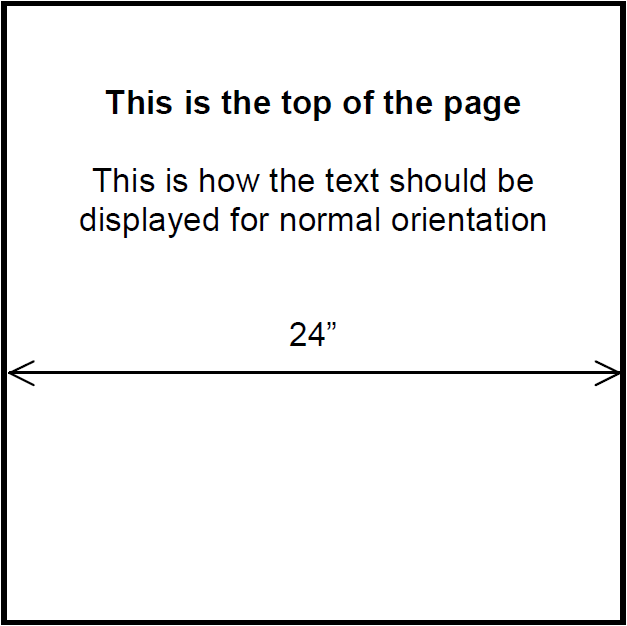
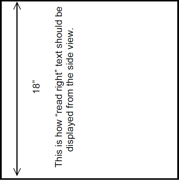
- Read right maps
A survey map should be oriented with the 24 inch dimension being the width and the 18 inch dimension being the height, otherwise known as viewing in a “landscape” position. While is it desirable to have the north arrow to the top of the page, sometimes it is not possible. In those cases, the north arrow should point to the left side of the map. “Read right” means that all information on the map reads from the top down and then from the right side. A simplistic drawing is shown below for your use.
- Basis of Bearing
We accept as the basis to be one of the following. Generally not acceptable as a “Basis of Bearings” are: assumed, magnetic or calculated.
- “True Bearing” based upon solar observation, it must be supported by data at and between two specific points.
- “True Bearing” based upon geodetic control, it must be supported by data at and between two specific points.
- Bearing as shown between two specific monuments from a prior survey, deed, road record, or other record document.
- Narratives
Narratives need to be sufficient to completely describe how the project boundary was resolved which survey monuments controlled the project, which deed and deed elements controlled the project and other items as noted in ORS 209.250. Basically, the narrative should explain “who, what, where, when, and why”.
- Delayed Monumentation Plats
Upon completion of the final monumentation, the County Surveyor must be notified in writing of that fact within five days of the setting of the monuments (ORS 92.070(3) (a)). Such notice can be provided by fax, email or letter and must be from the surveyor who signed and sealed the plat. Delayed monumentation subdivision plats: When it appears that a property line will be within an un-built sidewalk, the placement of offset monuments on the extension of the property line to the top of the curb may be required. The approved top of curb monuments currently acceptable is the Berntsen “BP2” or Mark-it mini plug “MPMPFT.” Such offsets, as well as any other offsets, must have prior approval of the County Surveyor.
- Encroachments/Hiatus Requirements County Code 11.01.02 provides that a surveyor “shall show all obvious encroachments or hiatuses created by deeds, buildings, fences, cultivation, occupation, previous surveys and plats and any other conditions that may indicate ownership lines as surveyed may be different than those shown on the survey.” This requirement is that you show encroachments on your property, and also requires disclosure for adjoining property. These may be shown on the initial boundary survey, partition plat, or be provided on a separate detail map. Please note that individual circumstances will determine whether or not an encroachment or hiatus will need to be shown on the final survey or plat, depending upon the resolution. Since each individual project is unique, this requirement will vary from project to project. In order to simplify the resolution and approval process of encroachments (especially fences) for your clients, please provide the following:
- Graphically and clearly show the encroachment or hiatus in relation to the boundary. If warranted, a detail may be necessary.
- Identify who owns the improvements causing the encroachment of hiatus (the owner of the subject property or the adjoining neighbor).
- Show the type of encroachment or hiatus: cyclone fence, stock fence, landscaping, paved driveway, etc. All encroachments must be resolved to the satisfaction of the County Surveyor’s office prior to final approval. Please note that an easement is generally not an acceptable resolution.
- Property Line Adjustments or re-plat?
Oregon Law and County Code provide the ability and methods for land owners to move or adjust their common boundary lines. The process begins with a Land Use Approval action taken by City or County Planning staff. It is the policy of the Clackamas County Surveyor’s Office to review all surveys received pursuant to Oregon Revised Statutes (ORS) Chapters 209 and 92; specifically 92.010 (9b), (12), (13); 92.040; 92.100; 92.180; 92.190 (2), (3) and (4). The proposed change may be approved by the County Surveyor as a “Property Line Adjustment” survey (PLA) with deeds, or a re-plat with subsequent deeds recorded for the newly recreated parcels or lots. (Re-platting is generally required when the change or reconfiguration in the common property boundary is a line that was created by a partition or subdivision plat). The client or surveyor must complete the application for a “Property Line Adjustment or Re-plat Evaluation” form. A copy of a sketch or tax map showing the proposed change is required with the application. After a determination is made by the County Surveyor, the client will be notified by staff via a letter or email.
- Riparian Issues
If you have a plat or survey with a stream, river or property with riparian rights, we have developed a “Navigability Statement” to be shown on appropriate plats. We recommend (not require) that surveyors add such a statement to records of survey that have riparian boundaries. There are two declared navigable rivers in Clackamas County. The Willamette River and the Sandy River from the mouth at the Columbia River to the mouth of the Salmon River. Several other tributaries of the Willamette below the Oregon City Falls have automatic navigability for the “portion with tidal influence”. If you have any questions, contact the County Surveyor or the Division of State Lands. (see next page for statements)
- Statement if river is not navigable:“Navigability Statement”The property ownership on this map / plat is depicted to the center or thread of the stream or river. A “Determination of Navigability” ** by the Division of State Lands / Oregon State Land Board has not been made. **Ownership of riparian (water) boundaries on streams and rivers in the State of Oregon is either to the center (thread) of the stream or river or, if it is navigable, to the ordinary high water line of that waterway. The official “Determination of Navigability” can only be made by the State Land Board.Alternative statement if river is navigable:“Navigability Statement”The property ownership on this map / plat is depicted to the ordinary high water of the stream or river. A “Determination of Navigability” **by the Division of State Lands / Oregon State Land Board was made on (insert date).** Ownership of riparian (water) boundaries on streams and rivers in the State of Oregon is either to the center (thread) of the stream or river or, if it is navigable to the ordinary high water line of that water way. The official “Determination of Navigability” can only be made by the State Land Board.
Public Land Corners
If a Public Land Corner controls, or is within, the boundary of a plat that is being surveyed, you are required by ORS 209.140(1) to notify the County Surveyor. Upon notification, we will research the corner, assure that it is referenced, and possibly remonument it prior to or after plat construction. It is imperative that the design of the plat protects the corner. Please assure that the plat design protects the PLSS monument and that the lot configuration does not place the corner in the middle of a building lot, which could result in the loss of a buildable lot to the developer. If you have any questions, please contact the County Surveyor.
Please contact our office early on your project. This can be done by submitting a completed “Request to Protect a Public Land Corner” form, a letter of notification, or a copy of the Preliminary Plat.
Records Research
- Not all survey and map records are available on our website. We have numerous old field books and records that are not easily converted to shape files for indexing. If you have a survey issue that involves older surveys, you will need to visit our office and search the card file index for those old records. Not all road records have been entered into our database, and therefore, you may need to visit our office to research those as well.
- As a Professional Land Surveyor, researching a project is a professional responsibility. Part of researching a project is knowing the purpose of the work and if you have obtained adequate information from that research to conduct the project. Our office staff would not know those limits or purposes. Our practice is not to conduct your work for you. However, we will assist if you need special help in researching some of our more obscure records. Of course, we are always pleased to send you specific information such as a survey or plat if you have the recording number or name. In those rare circumstances where we do provide research, there is an hourly fee. Such research must be approved by the County Surveyor.
- ORMAP (Oregon Map Project): ORMAP is the statewide GIS effort. A wealth of information is available ORMAP website. Specifically, ORMAP has created the Oregon Cadastral Map System Manual. See “Manual of Cadastral Map Standards, Concepts & Cartographic Procedures”.
